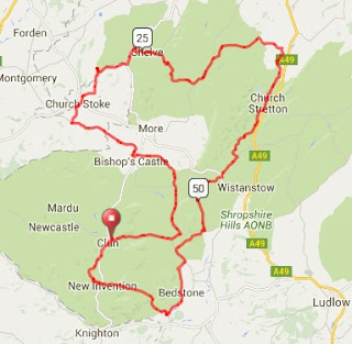
Route Description
The Long route riders will have plenty of warm up from the start in Clun all the way around to Bishop's Castle where a brief ramp in the town (Col du Bishop's Castle on Strava) takes them out on another long, fast road over to Chuchstoke. Just after Churchstoke they'll encounter the first and actually the most difficult obstacle - Weston Bank.
 |
| Weston Bank |
A remote, high road up on Stiperstones is their reward before a safe descent down towards Bridges and a ride north before the 2nd climb - known as Ker's Climb on Strava - a shorter hill up and over the northern end on the Long Mynd (great views) towards Picklescott and another fast descent.
 |
| Ker's Climb |
They then ride though the Strettons and out going south to encounter the short but nasty Minton Road climb. This is usually gravelly and can catch out the unaware. A drop through more gravelly roads gets them around to the long but gentle climb up to Edgton. Here they join up with the Inbetweener and Short route riders and all drop together towards Aston-on-Clun.
 |
| Hopton Castle |
Stats, map and profile
Imperial Units - 68 miles and 5,000ft total climb
Metric - 110km and 1,525m of climbing
Ride with GPS map - link
 |
| 68 mile/110km |
 |
| 5,000ft/1,525m |

No comments:
Post a Comment